
搜索结果: 91-105 共查到“国际动态 测绘科学技术”相关记录120条 . 查询时间(1.199 秒)
New National Institute of Standards and Technology Reference Material for Peptide Analysis
Peptide mass spectroscopy Measurements
<
2007/5/28
May 24, 2007,The National Institute of Standards and Technology (NIST) has issued its first-ever reference material designed to improve the performance and reliability of experiments to measure the ma...
Robotic research takes flight
electronics Geospatial Robotic
<
2007/5/24
May 03 2007,Robotic planes that help farmers monitor animal health, crop conditions and water use are flying out of the University of Nottingham’s newest overseas research centre.

22 May 2007,University of Southern Queensland first-year Spatial Science student Peter Worthington has been awarded a Geospatial Information and Technology Association (GITA) student bursary.

American Association for the Advancement of Science S&T Policy Forum Explores Privacy in an Era of Powerful Surveillance Tools(图)
Surveillance Tools
<
2007/5/15
14 May 2007,This is the age of watching and being watched. Cameras and other sensors have become so small they can be embedded in door knobs and other places people don’t notice, according to Daniel S...
National Institute of Standards and Technology Work Enhances Shop Floor Productivity
manufacturing measurements shop floor
<
2007/4/17
April 12, 2007,National Institute of Standards and Technology (NIST) engineers, together with colleagues from industry and other standards organizations have completed a five-part series of standards ...
Atlas of Science Literacy Completes Mapping of Science-Learning Pathways
Mapping Science Literacy
<
2007/4/9
29 March 2007,ST. LOUIS, Mo.―As K-12 teachers prepare to help students meet new science-learning requirements this fall, two of the world's largest science and science education organizations today jo...
food and drug administration Proposes to Allow the Use of Alternative Temperature-Indicating Devices for Processing Low-Acid Canned Foods
Temperature-Indicating Devices measuring
<
2007/3/30
March 13, 2007,The Food and Drug Administration (FDA) today issued a proposed rule which, if finalized, would benefit both consumers and the food industry by enabling manufacturers of heat-processed l...
national institute of standands and technology Report on U.S. Innovation Tags Measurement Challenges
Measurement System measurement infrastructure
<
2007/2/28
February 15, 2007,A new report from the National Institute of Standards and Technology (NIST), An Assessment of the United States Measurement System: Addressing Measurement Barriers to Accelerate Inno...
national institute of standands and technology Report Addresses Scientific and Technical Measurement Challenges Key to Sustaining U.S. Innovation
technical measurement
<
2007/2/13
Feb. 12, 2007,GAITHERSBURG, Md.―A new report based on an analysis of more than 700 scientific and technical measurement challenges facing U.S. industry today, calls on the public and private sectors t...
January 8, 2007,Google has joined a group of nineteen universities and national labs that are building the Large Synoptic Survey Telescope (LSST).
乌克兰采用新地标系统 精确版图尚待测定
新地标系统 大地测量学 “УСК-2000” “СК-42”
<
2007/1/5
科技日报基辅2007年1月4日报道,新年前夕,乌克兰自然保护部新闻局发布公告称,自2007年1月1日起,乌克兰改用新的国家大地测量坐标系“УСК-2000”。公告说,该新地标系统是以GPS观测为基础,对原用地标系“СК-42”加以改进形成的。此前,几乎所有前苏联国家均使用“СК-42”。“СК-42”坐标系是1942年制定的,是当时苏联技术设备水平的产物。到上世纪70年代,随着卫星和计算机技术的应...
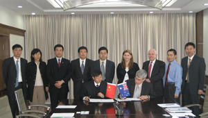
2006年11月1日,澳大利亚联邦科学与工业研究组织(CSIRO)数学和信息科学研究所所长卡默伦博士(Dr. Murray Cameron)等一行5人对中国测绘科学研究院进行了访问,签订了《澳大利亚联邦科学与工业研究组织与中国测绘科学研究院合作备忘录》。
国家测绘局副局长李维森出席了合作签约仪式并发表讲话。他代表国家测绘局向澳大利亚客人的到来表示热烈欢迎,并简要介绍了我国测绘部门的组织机...
《测绘科学》杂志被美国《剑桥科学文摘》收录
剑桥科学文摘 美国 测绘科学
<
2008/6/4
在广大专家、科技人员和读者的关注与厚爱下,在全体编辑人员的共同努力下,我院主办的《测绘科学》杂志的学术水平和影响力不断提高。继《测绘科学》被国内所有核心期刊检索机构收录并被国际六大检索机构之一的俄罗斯《文摘杂志》列为来源期刊之后, 2006年1月17日又被美国《剑桥科学文摘》(CSA)正式收录。这意味着《测绘科学》的学术水平、办刊能力和审稿制度正逐步与国际接轨,使作者可与国际学者进行直接交流。...
第14届地球空间信息科学国际会议开幕
地球空间信息科学 武汉大学 国家测绘局
<
2006/10/31
2006年10月28日上午,第14届地球空间信息科学国际会议在武汉海怡锦江大酒店开幕,来自美国、加拿大、英国、瑞士、德国、法国、中国等12个国家和地区的300多名专家与会。在为期两天的会议中,ISPRS、FIG、IAG、ICA、IEEE GRSS等组织的主席或副主席以及来自美国、加拿大、瑞士等国家和地区的10位知名专家和学者将分别作主题报告。