
�������: 31-45 ���鵽�����ʶ�̬ ����ѧ��������ؼ�¼120�� . ��ѯʱ��(0.438 ��)
NSF supports "Array of Things" prototype in Chicago
NSF Array of Things prototype Chicago
<
2016/12/13
University of Chicago scientists supported by the National Science Foundation (NSF) are collaborating with researchers at the Argonne National Laboratory to build out a wide-ranging urban se...
����ң���������š���������������
����ң������ �ų� ����
<
2016/11/3
���������Һ��պ���֣�NASA������2016��11��1�ձ��������º���������Ŀ�ѧ�һ�����������������ؿ�����Σ�ջ�ѧ���������ԭ���ң�м�����������һ�ֳ�Ϊ����������̽���ǡ���BILI����ԭ��װ�ã����������ԡ��š������Ǻ�̫��ϵ���������Ƿ������������
��������ѡ����˹��ѧԺ�⼮Ժʿ
����˹��ѧԺ �⼮Ժʿ ������ ʥ�˵ñ�
<
2021/11/4
Ī˹��ʱ��2016��10��27�գ��й���ѧԺң�������ֵ����о����о�Ա��������ѡΪ����˹��ѧԺ�⼮Ժʿ��
��òͼ��ʾ������ʯ����Դ��ͼ��
��ò ���� �ɿ� ��Դ
<
2016/11/1
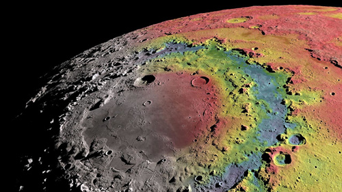
Լ38����ǰ�����������š��顱��һ�����쵮�������930�������ײ����ؾ���һֻ��ţ�ۡ�������ͣ��������Ŀɼ��߽磬��⻬���ڲ���3���ֲڵĻ�Χ���š���ʮ��������ѧ��һֱ��������Щ������Ҫ�ԣ������������Ǻ͵�������ײ�������Χ�����Կ��������ڣ���������֣�NASA�������ָ����ڲ�ʵ���ң�GRAIL��10��27�շ����ڡ���ѧ����־��һ�����������ͼ�������𰸲�����ˡ�
NSF,NGA release first unclassified digital elevation models of Alaska
NSF NGA first unclassified digital elevation models Alaska
<
2016/9/12
The National Science Foundation (NSF) and the National Geospatial-Intelligence Agency (NGA) have publicly released new three-dimensional topographic maps of Alaska in support of a White House Arctic i...
New technique settles old debate on highest peaks in US Arctic
old debate highest peaks US Arctic
<
2016/7/4
At 6190m, Denali is the uncontested highest peak in North America, but beyond the Arctic Circle, a debate remains as to which US mountain can be crowned the tallest. Depending on the scale of the map ...
�ɲ������仯�ı�Я��װ��������ͼ��
�������仯 ��Я��װ��
<
2016/4/5
Ӣ������Ȼ����־���չ�����һƪ����ѧ���ģ�������һ����Яʽ���ͳɱ��������ǣ��ɲ�������������ص�ʯ�͵Ⱦֲ�С�����Ŷ����������豸���жȻ����Բ�������ij�ϫ����Ӧ���ڵ����ѧ�����̡�ʯ�ͺ���Ȼ����̽�ͻ�������ϡ�������ȫ��Ϊ�������ٶ��ǣ����ڲ��������������ٶ��е�С�仯���ڿ�ѧӦ���ϣ����ԶԵؿ��α���й۲⣬�����ڻ�ɽѧ�У��������ܹ��ڻ�ɽ�緢ǰ������ɽ���ҽ��ѻ��̶ȣ����������ڹ�ҵ����ҵ�ϵ�...
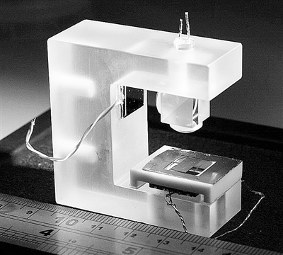
Ӣ������˹���ѧ�з�ӫ��ҩ������ͷ�ɾ�ȷɨ������
ӫ��ҩ������ͷ ɨ������
<
2015/12/30
Ӣ������˹���ѧ���չ��������¿�����һ��ҩ������ͷ������ͨҩ������ͷ��ȣ����ں�����ӫ������豸�ɾ�ȷɨ�賦��������
ҩ������ͷ��������չԽ��Խ���죬��ҽ�������Ӧ�ù㷺����ȴ�ͳ���ڿ�����˵�������ڽ��ܼ��Ĺ����л���ٺܶ�ʹ�ࡣ��Ŀǰ��ҩ������ͷ����ʹ����ͨ��С��Դ���������������������ǽ��������ij��ȡ�
Analysis exposes faster disintegration of major Greenland glacier
faster disintegration Greenland glacier
<
2015/12/7
A study appearing in Science magazine today shows a vast ice sheet in northeast Greenland has begun a phase of speeded-up ice loss, contributing to destabilization that will cause global sea-level ris...
Image Release: High-Def Radar Images of Near-Earth Asteroid
High-Def Radar Images Near-Earth Asteroid
<
2015/3/4
A team of astronomers using the National Science Foundation's Green Bank Telescope (GBT) in West Virginia and NASA's Deep Space Network radar transmitter at Goldstone, California, has made the most de...
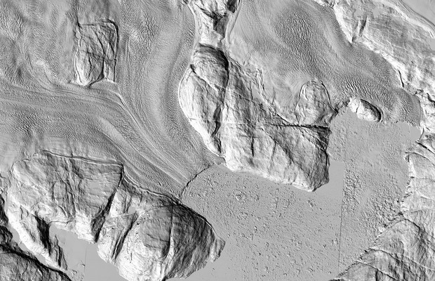
The highest-resolution satellite images ever taken of that region are making their debut. And while each individual pixel represents only one moment in time, taken together they show the ice sheet as ...
�����ػ�����ľ����ͼ��
�����ػ� ����� ľ����ͼ��
<
2014/11/26
����������Ա���ա����ơ���ľ����ŷ�ް���õ�һ�š�Ф����Ҳ���������Һ��պ���֣� NASA���״η����������ִ�ͼ����������İ汾������Ƭɫ�ʷ���������ߵ�������չʾ��ľ��������Ĵֵط�������˵����Щ����������ɫ�Ͱ�ɫ�ĵط��洢�������˵��Ϊ������ˮ�������ɫ�IJ����������Ũ�ȵġ��DZ��ɷ֡���ͼƬ�еġ������ش����Ƚ����γ�ȵ����������ⱻ�ձ���Ϊ�DZ������ߴ粻ͬʹȻ��
Better Bomb-Sniffing Technology
Bomb-Sniffing Technology
<
2014/11/10
Nov. 4, 2014 �C University of Utah engineers have developed a new type of carbon nanotube material for handheld sensors that will be quicker and better at sniffing out explosives, deadly gases and ille...
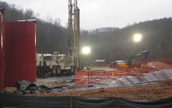
New tracers can identify frack fluids in the environment��ͼ��
environment dentify frack fluids
<
2014/12/1
Scientists have developed new geochemical tracers that can identify hydraulic fracturing flowback fluids that have been spilled or released into the environment.

New tracers can identify frack fluids in the environment��ͼ��
environment identify frack fluids
<
2014/12/1
DURHAM, N.C. �C Scientists have developed new geochemical tracers that can identify hydraulic fracturing flowback fluids that have been spilled or released into the environment.
�й��о����������а�-��
- ���ڼ���...
�й�ѧ���ڿ����а�-��
- ���ڼ���...
�����ѧ���л������а�-��
- ���ڼ���...
�й���ѧ���а�-��
- ���ڼ���...
�ˡ���-ƪ
- ���ڼ���...
�Ρ���-ƪ
- ���ڼ���...
��������-ƪ
- ���ڼ���...
�������� -ƪ
- ���ڼ���...
֪ʶҪ��-ƪ
- ���ڼ���...
���ʶ�̬-ƪ
- ���ڼ���...
��������-ƪ
- ���ڼ���...
ѧ��ָ��-ƪ
- ���ڼ���...
ѧ��վ��-ƪ
- ���ڼ���...