
搜索结果: 1-15 共查到“测绘科学技术 InSAR”相关记录98条 . 查询时间(0.109 秒)
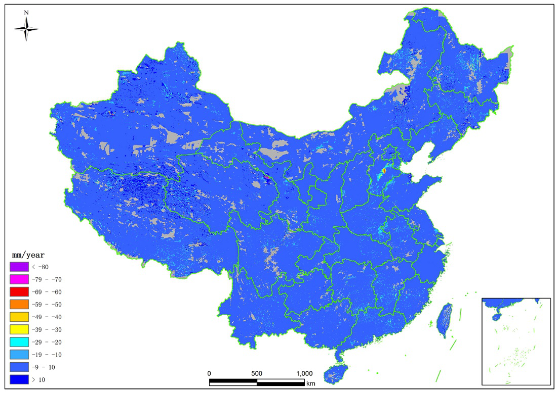
中国测绘科学研究院利用自主研发的InSAR超算平台完成了全国地表形变监测(图)
中国测绘科学研究院 地表形变监测 自然资源部
<
2023/11/10
近日,中国测绘科学研究院张永红研究团队利用自主研发的InSAR超算平台,成功获取了2021年9月至2022年4月全国地表形变一张图。

2021年12月10日下午,由测绘与空间信息学院主办的第8期智“绘”讲堂在J6楼434学术报告厅成功举办。本期智“绘”讲堂邀请到了中南大学教授、校学术委员会委员、国际数字地球学会中国国家委员会委员、微波遥感专业委员会副主任委员、中国地震学会大地测量与地震动力学专业委员会副主任委员、中国测绘学会矿山测量专业委员会副主任委员李志伟教授作了题为“高精度InSAR三维形变测量”的主题报告。受疫情影响,本次...
低轨卫星编队的精密轨道和基线确定是分布式InSAR卫星系统完成科学任务的重要前提。目前,基于GNSS数据的缩减动力学绝对和相对轨道确定是获得高精度轨道和基线产品的主要手段。本文利用天绘二号编队星载GPS实测数据,采用缩减动力学定轨方法进行编队卫星绝对和相对定轨研究。GPS数据质量分析表明,A星与B星接收机的信号跟踪能力和数据质量基本相当。通过对轨道机动进行常值加速度建模,可以有效消除机动对天绘二号...
多时相Sentinel-1A InSAR的连盐高铁沉降监测分析
时序InSAR 北斗导航卫星系统 连盐高铁 沉降监测 Sentinel-1A
<
2021/6/30
多时相InSAR技术具有探测大范围毫米级地表形变的能力,已被广泛应用于地面沉降监测。近几年,应用多时相InSAR技术监测以高铁为代表的大尺度人造线状地物形变备受关注。本文将C波段SAR数据用于高铁沿线路基形变监测,应用相位稳定性分析和改进的StaMPS技术来增加相干性点的密度和形变参数解算的稳定性。采用研究区时间跨度为21个月的47景Sentinel-1A数据,对连(云港)盐(城)高铁及其沿线区域...
我国首套自主知识产权超算InSAR系统实现全国地表形变监测(图)
自主知识产权 超算 InSAR系统 地表形变监测
<
2020/12/16
近日,中国科学院空天信息创新研究院王超研究员团队与计算技术研究所尤海航研究员团队,成功研制了我国首套自主知识产权的超算合成孔径雷达干涉测量(InSAR)系统,首次实现了全国尺度地表形变InSAR制图。地球表面因受地球内外动力的驱动,一直不停地运动和变化,从秒级的地震破裂到数十年甚至更长时间的断层蠕变,造成的地质灾害威胁着人类生命和财产安全。我国作为受地质灾害影响最严重的国家之一,地质灾害造成的损失...
随着不同成像参数SAR卫星不断发射升空以及新 的I nSAR技术不断出现,同一地区可以获取多尺度、多 源、异 质 的I nSAR地 表 形 变 监 测 数 据.将 这 些 多 源 I nSAR地表形变监测数据作为观测量,实际三维地表形 变作为未知参数,建立模型并解算,实现东西、南北和垂 直向地表形变监测,为地质灾害预报及监测提供更全面 的基础资料.本文以I nSAR三维地表形变解算为核心研 究内容...
ERROR ANALYSIS AND VALIDATION FOR INSAR HEIGHT MEASUREMENT INDUCED BY SLANT RANGE
InSAR DEM Slant Range Error Simulation Validation SRTM TanDEM-X
<
2018/5/16
InSAR technique is an important method for large area DEM extraction. Several factors have significant influence on the accuracy of height measurement. In this research, the effect of slant range meas...
A METHOD OF GENERATING DEM FROM DSM BASED ON AIRBORNE INSAR DATA
InSAR DSM Adaptive Threshold Segmentation DEM, Filtering
<
2018/5/15
Traditional methods of terrestrial survey to acquire DEM cannot meet the requirement of acquiring large quantities of data in real time, but the DSM can be quickly obtained by using the dual antenna s...
THE CORRELATION ANALYSIS OF SUBSIDENCE MONITORING BY D-INSAR AND THE CHANGE OF URBAN CONSTRUCTION LAND
DInSAR subsidence interferometry correlation
<
2017/7/12
The change of urban construction land affect the subsidence directly or indirectly, the method of D-InSAR has centimeter level or even millimeter accuracy that can provide a reliable and accurate data...
LANDSLIDE MONITORING USING INSAR TIME-SERIES AND GPS OBSERVATIONS, CASE STUDY: SHABKOLA LANDSLIDE IN NORTHERN IRAN
Landslide InSAR Time Series GPS ALOS
<
2017/7/13
Shabkola is a village located in Mazandaran province of northern Iran that suffers from the mass movement happening in the upstream. Deforestation and changes to land use are the main reasons for the ...
LAND SUBSIDENCE MONITORING USING PS-InSAR TECHNIQUE FOR L-BAND SAR DATA
Differential Interferometric synthetic (D-InSAR) Persistent Scatterer Interferometry Levelling Anthropogenic targets
<
2016/11/24
Differential SAR-Interferometry (D-InSAR) is one of the potential source to measure land surface motion induced due to underground coal mining. However, this technique has many limitation such as atmo...
MODEL ACCURACY COMPARISON FOR HIGH RESOLUTION INSAR COHERENCE STATISTICS OVER URBAN AREAS
Interferometric Synthetic Aperture Radar (InSAR) Coherence Statistics Model Accuracy Urban Areas
<
2016/11/24
The interferometric coherence map derived from the cross-correlation of two complex registered synthetic aperture radar (SAR) images is the reflection of imaged targets. In many applications, it can a...
SENTINEL-1 INSAR PROCESSING OF CORNER REFLECTOR INFORMATION IN THE NORTHERN-BOHEMIAN COAL BASIN
Sentinel-1 corner reflector InSAR mining area subsidence landslides
<
2016/11/24
The mining area previously monitored by TerraSAR-X InSAR is now monitored by Sentinel-1 InSAR. Although the processing of the IWS (TOPS) mode requires additional processing steps and the coregistratio...
BASELINE ESTIMATION ALGORITHM WITH BLOCK ADJUSTMENT FOR MULTI-PASS DUAL-ANTENNA INSAR
InSAR Baseline Estimation Phase Offset Block Adjustment Tie Point Ground Control Point
<
2016/11/23
Baseline parameters and interferometric phase offset need to be estimated accurately, for they are key parameters in processing of InSAR (Interferometric Synthetic Aperture Radar). If adopting baselin...
TOWARDS INSAR EVERYWHERE, ALL THE TIME, WITH SENTINEL-1
Sentinel-1 TOPS InSAR ECMWF Tectonics Volcanoes
<
2016/11/8
Sentinel-1A was launched in April 2014, and has been collecting data routinely over more than one year. Sentinel-1B is set for launch on 22 April 2016. The Sentinel-1 constellation has several advanta...