
�������: 16-30 ���鵽����ѧ Urban����ؼ�¼265�� . ��ѯʱ��(0.405 ��)
URBAN SHANTY TOWN RECOGNITION BASED ON HIGH-RESOLUTION REMOTE SENSING IMAGES AND NATIONAL GEOGRAPHICAL MONITORING FEATURES �C A CASE STUDY OF NANNING CITY
Gray-level co-occurrence matrix shanty town residential suitability nearest neighbour
<
2018/5/14
Urban shanty towns are communities that has contiguous old and dilapidated houses with more than 2000 square meters built-up area or more than 50 households. This study makes attempts to extract shant...
Spatiotemporal characteristics of urban air quality in China and geographic detection of their determinants
Air Quality Index (AQI) spatiotemporal characteristics geographic detector China
<
2018/4/9
Ambient air pollution brought by the rapid economic development and industrial production in China has exerted a significant influence on socio-economic activities and public health, especially in the...
EFFECT OF THE TRAINING SET CONFIGURATION ON SENTINEL-2-BASED URBAN LOCAL CLIMATE ZONE CLASSIFICATION
Label Noise Canonical Correlation Forests (CCFs) Local Climate Zones (LCZs) Sentinel-2 Spectral features Classification Open Street Map (OSM)
<
2018/6/4
As any supervised classification procedure, also Local Climate Zone (LCZ) mapping requires reliable reference data. These are usually created manually and inevitably include label noise, caused by the...
DETECTING FLU OUTBREAKS BASED ON SPATIOTEMPORAL INFORMATION FROM URBAN SYSTEMS �C DESIGNING A NOVEL STUDY
GIS epidemiology spatial epidemiology urban information systems seasonal influenza infectious disease surveillance and control
<
2018/4/18
This paper explores the application of real-time spatial information from urban transport systems to understand the outbreak, severity and spread of seasonal flu epidemics from a spatial perspective. ...
Rainfall-runoff risk characteristics of urban function zones in Beijing using the SCS-CN model
SCS-CN model urban function zone spatial cluster runoff risk
<
2018/4/9
Urbanization significantly increases the risk of urban flooding. Therefore, quantitative study of urban rainfall-runoff processes can provide a scientific basis for urban planning and management. In t...
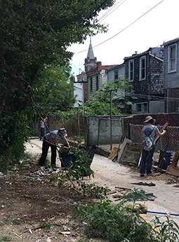
In urban Baltimore,poor neighborhoods have more mosquitoes��ͼ��
urban Baltimore poor neighborhoods more mosquitoes
<
2017/7/24
A new study published in the Journal of Medical Entomology reports that in Baltimore, Maryland, neighborhoods with high levels of residential abandonment are hotspots for tiger mosquitoes (Aedes albop...
��12����ʳ���ң�����ֻᣨ12th International Symposium Remote Sensing of Urban Areas��
��12�� ���ʳ���ң�� ���ֻ�
<
2017/1/20
The biennial international Joint Urban Remote Sensing Event (JURSE) is designed to be a forum of excellence where a selected group of researchers, practitioners, and students will present and discuss ...
Dietary glycemic index, glycemic load, and refined carbohydrates are associated with risk of stroke: a prospective cohort study in urban Chinese women
dietary carbohydrates glycemic index glycemic load stroke prospective cohort
<
2018/12/18
Background: Epidemiologic evidence on dietary carbohydrates and stroke risk remains controversial. Very few prospective cohort studies have been conducted in Asian populations, who usually consume a h...
ACCURACY OF MEASUREMENTS IN OBLIQUE AERIAL IMAGES FOR URBAN ENVIRONMENT
Aerial Oblique Images Accuracy Urban Mapping
<
2016/10/14
Oblique aerial images have been a source of data for urban areas for several years. However, the accuracy of measurements in oblique images during this time has been limited to a single meter due to t...
3D GEO-INFORMATION IN URBAN CLIMATE STUDIES
3D geo-information Urban climate Urban planning Urban climate characteristics Numerical models
<
2016/10/14
3D geo-information is essential for urban climate studies. It is obvious that both natural environment and built-up environment play the fundamental role in defining the climatic conditions for urban ...
3D PROCEDURAL RECONSTRUCTION OF URBAN LANDSCAPES FOR THE PURPOSES OF A WEB-BASED HISTORICAL ATLAS
History Historical Memory Historical Atlas Cartography 3D Model Procedural Modelling
<
2016/10/14
The ��Czech Historical Atlas�� project is a part of the NAKI II programme of the Czech Ministry of Culture and aims to create the following two main outputs: a printed atlas of the Czech history in the ...
SEMI-AUTOMATED APPROACH FOR MAPPING URBAN TREES FROM INTEGRATED AERIAL LiDAR POINT CLOUD AND DIGITAL IMAGERY DATASETS
Extraction Integrated Airborne LiDAR Multispectral Image Urban Trees
<
2016/10/14
Mapping of trees plays an important role in modern urban spatial data management, as many benefits and applications inherit from this detailed up-to-date data sources. Timely and accurate acquisition ...
GEOSPATIAL ANALYSIS OF URBAN LAND USE PATTERN ANALYSIS FOR HEMORRHAGIC FEVER RISK �C A REVIEW
Land Use Land Cover Hemorrhagic Fever Vector Dengue Fever Malaria Lassa Fever
<
2016/10/14
Human modification of the natural environment continues to create habitats in which vectors of a wide variety of human and animal pathogens (such as Plasmodium, Aedes aegypti, Arenavirus etc.) thrive ...
Small-quantity, lipid-based nutrient supplements provided to women during pregnancy and 6 mo postpartum and to their infants from 6 mo of age increase the mean attained length of 18-mo-old children in semi-urban Ghana: a randomized controlled trial
lipid-based nutrient supplements child growth home fortification multiple micronutrients supplementation
<
2018/12/14
Background: Childhood stunting usually begins in utero and continues after birth; therefore, its reduction must involve actions across different stages of early life.
The impact of impervious surfaces on ecohydrology and health in urban ecosystems of Bansk�� Bystrica (Slovakia)
built environment runoff soil sealing
<
2016/2/22
The risks of accelerated runoff and its larger amounts brought by urbanisation include increased flood flows and pollution of downstream ecosystems. One of the most significant permanent effect of urb...
�й��о����������а�-��
- ���ڼ���...
�й�ѧ���ڿ����а�-��
- ���ڼ���...
�����ѧ���л������а�-��
- ���ڼ���...
�й���ѧ���а�-��
- ���ڼ���...
�ˡ���-ƪ
- ���ڼ���...
�Ρ���-ƪ
- ���ڼ���...
��������-ƪ
- ���ڼ���...
�������� -ƪ
- ���ڼ���...
֪ʶҪ��-ƪ
- ���ڼ���...
���ʶ�̬-ƪ
- ���ڼ���...
��������-ƪ
- ���ڼ���...
ѧ��ָ��-ƪ
- ���ڼ���...
ѧ��վ��-ƪ
- ���ڼ���...