
搜索结果: 1-15 共查到“摄影测量与遥感技术 GNSS”相关记录19条 . 查询时间(0.21 秒)
自然资源部大地测量数据处理中心完成甘肃省北斗地基增强系统建设项目GNSS数据处理工作
数据中心 北斗地基 数据处理
<
2023/11/13
近日,自然资源部大地测量数据处理中心完成了“甘肃省北斗地基增强系统建设项目”GNSS数据处理及成果质检工作。
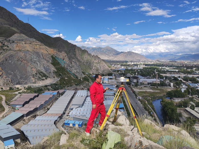
第一大地测量队拉萨市市域空间基准建设项目全面启动GNSS观测(图)
基准站 拉萨市 自然资源部
<
2023/11/13
由自然资源部第一大地测量队承担的拉萨市市域空间基准建设项目(以下简称拉萨项目)13座新建基准站观测墩建造已全部完成,站点仪器设备也已全部安装调试并开始运行,并于8月27日全面启动GNSS观测。
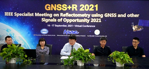
IEEE GNSS+R 2021国际会议成功举行(图)
GNSS-R领域;IR载荷研制;遥感学会
<
2021/10/26
2021年9月14日,IEEE GNSS+R 2021国际会议在北京召开,这是该GNSS-R领域顶级学术会议首次在亚洲国家举办。会议由电子与电气工程师协会地球科学与遥感学会(IEEE GRSS)主办,中国科学院国家空间科学中心(NSSC)和中国科学院青年创新促进会(YIPA)承办,聚集了GNSS-R和GNSS RO领域的国际知名科学家,共同探讨新一代GNSS遥感技术的发展趋势。
中国石油大学(华东)2021年硕士研究生初试自命题科目GNSS、RS、GIS原理与方法考试大纲
中国石油大学(华东) 2021年 硕士研究生 初试 自命题科目 GNSS、RS、GIS原理与方法 考试大纲
<
2020/10/14
中国石油大学(华东)2021年硕士研究生初试自命题科目GNSS、RS、GIS原理与方法考试大纲。
FULLY AUTOMATIC FEATURE-BASED REGISTRATION OF MOBILE MAPPING AND AERIAL NADIR IMAGES FOR ENABLING THE ADJUSTMENT OF MOBILE PLATFORM LOCATIONS IN GNSS-DENIED URBAN ENVIRONMENTS
Mobile Mapping Feature Matching Image Orientation Adjustment
<
2017/7/12
Mobile Mapping (MM) has gained significant importance in the realm of high-resolution data acquisition techniques. MM is able to record georeferenced street-level data in a continuous (laser scanners)...
GEOREFERENCING IN GNSS-CHALLENGED ENVIRONMENT: INTEGRATING UWB AND IMU TECHNOLOGIES
Ultra-wide band GNSS-denied positioning UXO mapping
<
2017/7/12
Acquiring geospatial data in GNSS compromised environments remains a problem in mapping and positioning in general. Urban canyons, heavily vegetated areas, indoor environments represent different leve...
INTEGRATION OF KINECT AND LOW-COST GNSS FOR OUTDOOR NAVIGATION
Kinect GNSS Low-cost Navigation Outdoor
<
2016/11/11
Since its launch on the market, Microsoft Kinect sensor has represented a great revolution in the field of low cost navigation, especially for indoor robotic applications. In fact, this system is endo...
1st International Conference on GNSS+ (ICG+2016)
multi-Global Navigation Satellite Systems signals
<
2016/7/22
Nowadays, multi-Global Navigation Satellite Systems (GNSS) have been developed and widely used, including US's GPS, Russia's GLONASS, China's BeiDou and EU's Galileo as well as regional systems, such ...
THE PERFORMANCE OF A TIGHT INS/GNSS/PHOTOGRAMMETRIC INTEGRATION SCHEME FOR LAND BASED MMS APPLICATIONS IN GNSS DENIED ENVIRONMENTS
Direct georeferencing Constraint Mobile Mapping System Control points
<
2016/7/5
The early development of mobile mapping system (MMS) was restricted to applications that permitted the determination of the elements of exterior orientation from existing ground control. Mobile mappin...
INTRODUCTION OF A PHOTOGRAMMETRIC CAMERA SYSTEM FOR RPAS WITH HIGHLY ACCURATE GNSS/IMU INFORMATION FOR STANDARDIZED WORKFLOWS
UAV RPAS Modular Airborne Camera System MACS Metric Camera Direct Georeference RTK-GNSS
<
2016/3/25
In this paper we present the evaluation of DLR’s modular airborne camera system MACS-Micro for remotely piloted aircraft system (RPAS) with a maximum takeoff weight (MTOW) less than 5kg. The main focu...
Tight Integration of GNSS Post-processed Virtual Reference Station with Inertial Data for Increased Accuracy and Productivity of Airborne Mapping
Aerial Survey GNSS/INS Integration IMU
<
2015/12/17
GNSS-Aided Inertial Navigation for Direct Georeferencing of aerial imagery and other sensors such as LIDAR is a well accepted
technology that has been in use since the mid 1990’s. Position accuracies...
EFFECTS OF OCEAN TIDE MODELS ON GNSS-ESTIMATED ZTD AND PWV IN TURKEY
Precipitable Water Vapour Ocean Tide Models GNSS Zenith Tropospheric Delay
<
2016/1/15
Global Navigation Satellite System (GNSS) observations can precisely estimate the total zenith tropospheric delay (ZTD) and precipitable water vapour (PWV) for weather prediction and atmospheric resea...
A REDUNDANT GNSS-INS LOW-COST UAV NAVIGATION SOLUTION FOR PROFESSIONAL APPLICATIONS
UAV sreliable navigation sredundant IMUs sGNSS beamforming sclose coupling
<
2015/9/21
This paper presents the current results for the FP7 GINSEC project. Its goal is to build a pre-commercial prototype of a low-cost, accurate and reliable system for the professional UAV market. Low-cos...
MULTI-GNSS RECEIVER FOR AEROSPACE NAVIGATION AND POSITIONING APPLICATIONS
Aerial Land Navigation Georeferencing GPS/INS Interoperability Hardware Systems
<
2014/4/21
The upcoming Galileo system opens a wide range of new opportunities in the Global Navigation Satellite System (GNSS) market. However, the characteristics of the future GNSS signals require the develop...
THE PERFORMANCE OF A TIGHT INS/GNSS/PHOTOGRAMMETRIC INTEGRATION SCHEME FOR LAND BASED MMS APPLICATIONS IN GNSS DENIED ENVIRONMENTS
Direct georeferencing LC TC MMS
<
2014/4/25
Nowadays the most common technologies used for positioning and orientation of a mobile mapping system include using Global Navigation Satellite System (GNSS) as a major positioning sensor and Inertial...