
�������: 1-15 ���鵽��terrain����ؼ�¼198�� . ��ѯʱ��(0.093 ��)
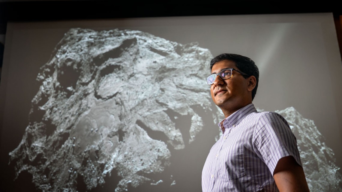
Cornell scientists show how terrain evolves on an icy comet��ͼ��
�������� �����ݱ� ���亽����
<
2023/5/19
With an eye toward a possible return mission years in the future, Cornell astronomers have shown how smooth terrains �C a good place to land a spacecraft and to scoop up samples �C evolve on the icy wor...

All-terrain microrobot flips through a live colon��ͼ��
All-terrain microrobot flips through live colon
<
2020/10/30
A rectangular robot as tiny as a few human hairs can travel throughout a colon by doing back flips, Purdue University engineers have demonstrated in live animal models.Why the back flips? Be...
��������ѧ��`������������������ġ�PM2.5 Pollution in China and How It Has Been Exacerbated by Terrain and Meteorological Conditions��
��������ѧ�� �` ����������� ���� PM2.5
<
2017/6/28
���գ���������ѧ��`��Bulletin of the American Meteorological Society�����߷����˱���ʦ����ѧ����������Ŷ���Ϊ��PM2.5 Pollution in China and How It Has Been Exacerbated by Terrain and MeteorologicalConditions���������о��ɹ������������ΪͨѶ���ߡ����о�...
Atmospheric scientists conduct field experiment to study wind flow over complex mountain terrain
Atmospheric scientists conduct field experiment wind flow over complex mountain terrain
<
2017/7/21
Over the past month, researchers have descended on Portugal's Vale Do Cobrão near the Spanish border to study the valley's wind flow patterns.The international project, known as Perdigão aft...
AN EFFICIENT METHOD TO CREATE DIGITAL TERRAIN MODELS FROM POINT CLOUDS COLLECTED BY MOBILE LiDAR SYSTEMS
Mobile systems point cloud Digital Terrain Models LiDAR Delaunay triangulation Laplacian operator
<
2017/7/12
The digital terrain models (DTM) assume an essential role in all types of road maintenance, water supply and sanitation projects. The demand of such information is more significant in developing count...
POINTING ANGLE CALIBRATION OF ZY3-02 SATELLITE LASER ALTIMETER USING TERRAIN MATCHING
ZY3-02 Satellite Laser Altimeter Geometric Calibration Terrain Matching GLAS
<
2017/7/12
After GLAS (Geo-science Laser Altimeter System) loaded on the ICESat (Ice Cloud and land Elevation Satellite), satellite laser altimeter attracts more and more attention. ZY3-02 equipped with the Chin...
Research on forest terrain roughness as a source of dynamic action on the vehicle
forest soils micro-profile correlation analysis power spectral density
<
2018/3/6
The issue of terrain conditions is very complex and its description is approached from different perspectives and with
different objectives. Because it consists of the gathering of basic information ...
2017������λ�����ר����飨Special Session on Rugged-Terrain Robotics - Applications, Methods and Systems��
2017 ����λ����� ר�����
<
2017/2/15
This special session solicits contributions on applications, methods and systems for robots that are built for and that operate in rugged terrain. The scope of this special session includes research w...
SPATIAL RESOLUTION EFFECTS OF DIGITAL TERRAIN MODELS ON LANDSLIDE SUSCEPTIBILITY ANALYSIS
Landslide Susceptibility analysis Certainty factor Artificial neural networks Remote sensing
<
2016/11/30
The purposes of this study are to identify the maximum number of correlated factors for landslide susceptibility mapping and to evaluate landslide susceptibility at Sihjhong river catchment in the sou...
LANDSLIDES IDENTIFICATION USING AIRBORNE LASER SCANNING DATA DERIVED TOPOGRAPHIC TERRAIN ATTRIBUTES AND SUPPORT VECTOR MACHINE CLASSIFICATION
Airborne laser scanning support vector machine landslide mapping Pricncipal Component Analysis
<
2016/11/30
Since the availability of high-resolution Airborne Laser Scanning (ALS) data, substantial progress in geomorphological research, especially in landslide analysis, has been carried out. First and secon...
ANALYSIS OF INFLUENCE OF TERRAIN RELIEF ROUGHNESS ON DEM ACCURACY GENERATED FROM LIDAR IN THE CZECH REPUBLIC TERRITORY
DEM LIDAR ALS Accuracy Micro-relief Terrain slope Terrain roughness
<
2016/11/8
Digital elevation models are today a common part of geographic information systems and derived applications. The way of their creation is varied. It depends on the extent of area, required accuracy, d...
COMPARISON OF UAV-ENABLED PHOTOGRAMMETRY-BASED 3D POINT CLOUDS AND INTERPOLATED DSMs OF SLOPING TERRAIN FOR ROCKFALL HAZARD ANALYSIS
Drones UAV Photogrammetry 3D point clouds Rockfall Structure-from-Motion DSM
<
2016/10/14
UAVs are expected to be particularly valuable to define topography for natural slopes that may be prone to geological hazards, such as landslides or rockfalls. UAV-enabled imagery and aerial mapping c...
Irregular Morphing for Real-Time Rendering of Large Terrain
Large Terrain Rendering LOD View-Dependent Wavelet QuadTree
<
2016/7/28
The following paper proposes an alternative approach to the real-time adaptive triangulation problem. A new region-based multi-resolution approach for terrain rendering is described which improves on-...
DIGITAL TERRAIN MODELS FROM MOBILE LASER SCANNING DATA IN MORAVIAN KARST
Mobile Mapping Digital Terrain Model 3D Point Cloud DMR 4G
<
2016/7/27
During the last ten years, mobile laser scanning (MLS) systems have become a very popular and efficient technology for capturing reality in 3D. A 3D laser scanner mounted on the top of a moving vehicl...
DIGITAL TERRAIN FROM A TWO-STEP SEGMENTATION AND OUTLIER-BASED ALGORITHM
Digital Elevation Models DEM DTM DSM ground filter surface fitting point cloud filtering
<
2016/7/27
We present a novel ground filter for remotely sensed height data. Our filter has two phases: the first phase segments the DSM with a slope threshold and uses gradient direction to identify candidate g...
�й��о����������а�-��
- ���ڼ���...
�й�ѧ���ڿ����а�-��
- ���ڼ���...
�����ѧ���л������а�-��
- ���ڼ���...
�й���ѧ���а�-��
- ���ڼ���...
�ˡ���-ƪ
- ���ڼ���...
�Ρ���-ƪ
- ���ڼ���...
��������-ƪ
- ���ڼ���...
�������� -ƪ
- ���ڼ���...
֪ʶҪ��-ƪ
- ���ڼ���...
���ʶ�̬-ƪ
- ���ڼ���...
��������-ƪ
- ���ڼ���...
ѧ��ָ��-ƪ
- ���ڼ���...
ѧ��վ��-ƪ
- ���ڼ���...