
搜索结果: 1-15 共查到“airborne”相关记录680条 . 查询时间(0.171 秒)
Democratic Republic of the Congo Tropical Forest Canopy Height and Aboveground Biomass Estimation with Landsat-8 Operational Land Imager (OLI) and Airborne LiDAR Data: The Effect of Seasonal Landsat Image Selection
Airborne LiDAR Landsat-8 tropical forest canopy height aboveground biomass Congo Basin Forest
<
2023/12/19
Inventories of tropical forest aboveground biomass (AGB) are often imprecise and sparse. Increasingly,?airborne?Light Detection And Ranging (LiDAR) and satellite optical wavelength sensor data are use...
Classifying wetland-related land cover types and habitats using fine-scale lidar metrics derived from country-wide Airborne Laser Scanning
Habitat classification Phragmites australis reedbed structural heterogeneity vegetation complexity wetland conservation
<
2023/12/19
Mapping 3D vegetation structure in wetlands is important for conservation and monitoring. Openly accessible country-wide Airborne Laser Scanning (ALS) data-using light detection and ranging (lidar) te...
Airborne LiDAR Intensity Correction Based on a New Method for Incidence Angle Correction for Improving Land-Cover Classification
airborne LiDAR intensity correction LiDAR intensity
<
2023/12/6
Light detection and range (LiDAR) intensity is an important feature describing the characteristics of a target. The direct use of original intensity values has limitations for users, because the same ...
Semi-Automated Semantic Segmentation of Arctic Shorelines Using Very High-Resolution Airborne Imagery, Spectral Indices and Weakly Supervised Machine Learning Approaches
land water segmentation remote sensing deep learning sparse labels
<
2023/12/5
Precise coastal shoreline mapping is essential for monitoring changes in erosion rates, surface hydrology, and ecosystem structure and function. Monitoring water bodies in the Arctic National Wildlife...
Using Airborne Lidar, Multispectral Imagery, and Field Inventory Data to Estimate Basal Area, Volume, and Aboveground Biomass in Heterogeneous Mixed Species Forests: A Case Study in Southern Alabama
laser forestry allometry parametric non-parametric modeling 3DEP Alabama
<
2023/11/30
Airborne light detection and ranging (lidar) has proven to be a useful data source for estimating forest inventory metrics such as basal area (BA), volume, and aboveground biomass (AGB) and for produc...
Integrating UAV-SfM and Airborne Lidar Point Cloud Data to Plantation Forest Feature Extraction
UAV-ALS point cloud georeferencing improved ICP via invariant ground surface feature tree parameterization airborne lidar sensing UAV optical sensing sustainable timber production
<
2023/11/30
A low-cost but accurate remote-sensing-based forest-monitoring tool is necessary for regularly inventorying tree-level parameters and stand-level attributes to achieve sustainable management of timber...

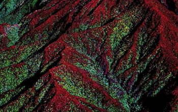
Molecular basis of methyl-salicylate-mediated plant airborne defense(图)
methyl-salicylate airborne defense 植物病毒
<
2024/4/27
Molecular basis of methyl-salicylate-mediated plant airborne defense。
Airborne science discovers complex geomorphic controls on Bornean forests(图)
Airborne science complex geomorphic controls Bornean forests
<
2020/6/5
Tropical forests contain some of the most biodiverse and dynamic ecosystems in the world.The influence of precipitation, temperature, and soils is especially noticeable when comparing the towering tre...
ROAD NETWORK MAPPING USING AIRBORNE LiDAR DATA
Road Airborne Laser Scanning (ALS) Intensity
<
2019/2/28
The accurate, detailed and up-to-date road information is highly essential geo-spatial databases for transportation, smart city and other related applications. Thus, the main objective of this researc...
BUILDING CLASSIFICATION OF VHR AIRBORNE STEREO IMAGES USING FULLY CONVOLUTIONAL NETWORKS AND FREE TRAINING SAMPLES
Building Classification VHR Airborne Stereo Images FCN Base Map Mislabels Free Training Samples Fine Tuning Atrous Convolution
<
2018/11/9
Semantic segmentation, especially for buildings, from the very high resolution (VHR) airborne images is an important task in urban mapping applications. Nowadays, the deep learning has significantly i...
EVALUATION OF AIRBORNE L- BAND MULTI-BASELINE POL-INSAR FOR DEM EXTRACTION BENEATH FOREST CANOPY
Digital Elevation Model, SAR, Multi-baseline Pol-InSAR, TomoSAR, Forest canopy, Scattering characteristics separation
<
2018/5/14
DEM beneath forest canopy is difficult to extract with optical stereo pairs, InSAR and Pol-InSAR techniques. Tomographic SAR (TomoSAR) based on different penetration and view angles could reflect vert...
ABOVEGROUND BIOMASS ESTIMATION USING RECONSTRUCTED FEATURE OF AIRBORNE DISCRETE-RETURN LIDAR BY AUTO-ENCODER NEURAL NETWORK
Aboveground Biomass (AGB) Estimation Discrete-Return LiDAR Regression Auto-Encoder Neural Network
<
2018/5/14
Aboveground biomass (AGB) estimation is critical for quantifying carbon stocks and essential for evaluating carbon cycle. In recent years, airborne LiDAR shows its great ability for highly-precision A...
FEATURE RELEVANCE ASSESSMENT OF MULTISPECTRAL AIRBORNE LIDAR DATA FOR TREE SPECIES CLASSIFICATION
Multispectral Lidar 3D point clouds Intensity Tree Species Classification Feature Analysis
<
2018/5/11
The presented experiment investigates the potential of Multispectral Laser Scanning (MLS) point clouds for single tree species classification. The basic idea is to simulate a MLS sensor by combining t...
A THRESHOLD-FREE FILTERING ALGORITHM FOR AIRBORNE LIDAR POINT CLOUDS BASED ON EXPECTATION-MAXIMIZATION
Airborne LiDAR Point clouds Filtering Ground points Expectation-maximization Intensity
<
2018/5/14
Filtering is a key step for most applications of airborne LiDAR point clouds. Although lots of filtering algorithms have been put forward in recent years, most of them suffer from parameters setting o...
ALTERATION MINERALS EXTRACTION USING AIRBORNE HYPERSPECTRAL DATA CASI AND SASI IN WUYI METALLOGENIC BELT, CHINA
Alteration Minerals Airborne Hyperspectral Wuyi Metallogenic Belt Spectral Feature MTMF CASI and SASI
<
2018/5/14
Hydrothermal alteration is an important content in the study of epithermal deposit, and its deep part is often accompanied by porphyry mineralization. The objective of research is to mapping the alter...