
搜索结果: 1-15 共查到“Digital Elevation Models”相关记录43条 . 查询时间(0.125 秒)
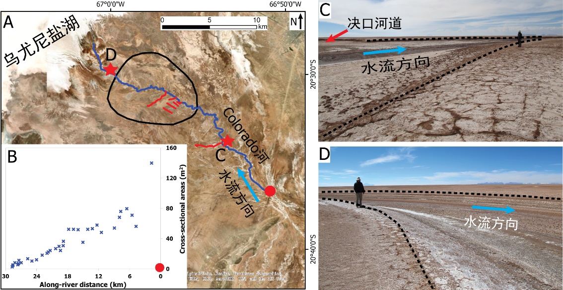
中国地质大学科学技术发展院李嘉光* 等,资源学院. Journal of Hydrology(2020), Digital Elevation Models for topographic characterisation and flood flow modelling along low-gradient, terminal dryland rivers: A comparison of spaceborne datasets for the Río Colorado, Bolivia(图)
精确表征;极低;缓河流;末端;地形;模拟河道;洪水;漫溢
<
2021/10/15
近日,国际知名期刊Journal of Hydrology在线刊发了中国地质大学资源学院李嘉光副教授团队在陆相湖盆边缘河流末端沉积体系研究的最新成果――Digital Elevation Models for topographic characterisation and flood flow modelling along low-gradient, terminal dryland rive...
SUBAQUATIC DIGITAL ELEVATION MODELS FROM UAV-IMAGERY
UAV, DEM underwater multi-media bundle-adjustment
<
2018/6/4
The paper presents an approach for the generation of digital elevation models (DEMs) of underwater areas from aerial images. Standard software-products do not provide the possibility to measure correc...
DETERMINING THE SUITABILITY OF DIFFERENT DIGITAL ELEVATION MODELS AND SATELLITE IMAGES FOR FANCY MAPS. AN EXAMPLE OF CYPRUS
Fancy map Image DEM Relief shading hillshading image merge color composite
<
2016/11/8
The article describes the possibility of developing an overall map of the selected area on the basis of publicly available data. Such a map would take the form designed by the author with the colors t...
NSF,NGA release first unclassified digital elevation models of Alaska
NSF NGA first unclassified digital elevation models Alaska
<
2016/9/12
The National Science Foundation (NSF) and the National Geospatial-Intelligence Agency (NGA) have publicly released new three-dimensional topographic maps of Alaska in support of a White House Arctic i...
THE NEED OF NESTED GRIDS FOR AERIAL AND SATELLITE IMAGES AND DIGITAL ELEVATION MODELS
Orthoimages DEM Geographic Grid
<
2016/7/8
Usual workflows for production, archiving, dissemination and use of Earth observation images (both aerial and from remote sensing satellites) pose big interoperability problems, as for example: non-al...
The scheme for the database building and updating of 1:10000 Digital Elevation Models
Geospatial data DEM Photogrammetric sampling Cartographic digitisation Specification
<
2016/5/20
The National Bureau of Surveying & Mapping of China has planned to speed up its development of spatial data infrastructure (SDI) in the coming few years. This SDI consists of four types of digital pro...
Mosaicking of Digital Elevation Models derived by SAR interferometry
Mosaicking Digital Elevation Models derived SAR interferometry
<
2016/5/20
In the framework of the Shuttle Radar Topography Mapper (SRTM) Mission the generation of high-quality Digital Elevation Models (DEMs) with global coverage of the earth's surface is envisaged. In this ...
Comparison of Digital Elevation Models Generated from SPOT-5 HRS Stereo Data and CARTOSAT-1 Stereo Data
Cartosat-1 SPOT-5 rigorous sensor model RPC stereo DEM
<
2016/1/25
SPOT-5 and Cartosat-1 are mapping satellites with high resolution and along-track stereo capability. This paper describes the work
carried out towards the qualitative and quantitative comparison of t...
Fusion of lidar and photogrammetric generated Digital Elevation Models
Multisource data Fusion Integration Quality Control Digital Elevation Model
<
2016/1/25
The fusion of digital surfaces, their optimal combination into a new single dataset, is a crucial topic in the geomatic sciences. Nowadays,
sensors and processing techniques provide for the same site...
Refinement of Urban Digital Elevation Models from Very High Resolution Stereo Satellite Images
VHR satellite data stereo images digital surface models optimization dense stereo matching occlusion mask blunder elimination
<
2016/1/25
Digital elevation models (DEM) of high resolution and high quality are required for many applications like urban modeling, readiness for
catastrophes or disaster assessment. A good source for the de...
Validating Global Digital Elevation Models with Degree Confluence Project Information and ASTER-DEM on Geo Grid
DEM Validation GTOPO30 SRTM ASTER Data Integration
<
2015/12/18
There are two major freely available global digital elevation datasets, known as GTOPO30 and SRTM. To know the accuracies of those data in global scale, relative evaluation of these data and validatio...
Digital Elevation Models of Great Wall by a Combination of Airborne and Terrestrial LIDAR
Lidar DEM Photogrammetry Scanner Accuracy GPS
<
2015/12/18
The Great Wall is one of the biggest man-made wonders of the world! The wall consists of bricks made by different dynasties and built on thousands of kilometers of steep mountain terrain. It has many ...
A New Data Structure for Refined Digital Elevation Models
GIS Modeling Visualization Data Structure DEM/DTM
<
2015/12/16
A new DEM called Hybrid Mesh DEM (HM-DEM) with a hybrid mesh is put forth to improve the DEM’s capacity of representation of different kinds of micro-terrains and complex landscapes. The conceptual mo...
PREDICTION OF WIND SPEEDS BASED ON DIGITAL ELEVATION MODELS USING BOOSTED REGRESSION TREES
Digital Elevation Model Wind Speed Non-Parametric Regression
<
2016/1/15
In this paper a new approach is presented to predict maximum wind speeds using Gradient Boosted Regression Trees (GBRT). GBRT are a non-parametric regression technique used in various applications, su...
THE RATIONAL POLYNOMIAL COEFFICIENTS MODIFICATION USING DIGITAL ELEVATION MODELS
Rational Polynomial Coefficients Digital Elevation Models Ground Control Points DEM Matching
<
2016/1/15
The high-resolution satellite imageries (HRSI) are as primary dataset for different applications such as DEM generation, 3D city mapping, change detection, monitoring, and deformation detection. The g...