
搜索结果: 1-15 共查到“农学 laser”相关记录33条 . 查询时间(0.166 秒)
The Global Ecosystem Dynamics Investigation: High-resolution laser ranging of the Earth’s forests and topography
lidar ecosystem structure GEDI biomass
<
2024/1/22
Obtaining accurate and widespread measurements of the vertical structure of the Earth’s forests has been a long-sought goal for the ecological community. Such observations are critical for accurately ...
Classifying wetland-related land cover types and habitats using fine-scale lidar metrics derived from country-wide Airborne Laser Scanning
Habitat classification Phragmites australis reedbed structural heterogeneity vegetation complexity wetland conservation
<
2023/12/19
Mapping 3D vegetation structure in wetlands is important for conservation and monitoring. Openly accessible country-wide Airborne Laser Scanning (ALS) data-using light detection and ranging (lidar) te...
Voxel-Based Automatic Tree Detection and Parameter Retrieval from Terrestrial Laser Scans for Plot-Wise Forest Inventory
remote sensing forest inventory terrestrial laser scanning point cloud processing automatic tree extraction stem curve tree height TLS benchmarking
<
2023/12/6
This paper presents a fully automatic method addressing tree mapping and parameter extraction (tree position, stem diameter at breast height, stem curve, and tree height) from terrestrial laser scans ...
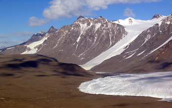
Laser mapping project shows effects of physical changes in Antarctica's Dry Valleys(图)
Laser mapping project physical changes Antarctica Dry Valleys
<
2017/9/4
Researchers funded by the National Science Foundation (NSF) have publicly released high-resolution maps of Antarctica's McMurdo Dry Valleys, a globally unique polar desert.The high-resolution maps cov...
Estimation of diameter at breast height from mobile laser scanning data collected under a heavy forest canopy
mobile mapping system clustering point cloud circle fit
<
2018/3/6
Mobile laser scanning (MLS) is time-efficient technology of geospatial data collection that proved its ability to provide
accurate measurements in many fields. Mobile innovation of the terrestrial la...
Accuracy of Structure from Motion models in comparison with terrestrial laser scanner for the analysis of DBH and height influence on error behaviour
hand-held digital camera point cloud stem optimization image segmentation photogrammetry
<
2016/9/2
With the advantage of Structure from Motion technique, we reconstructed three-dimensional structures from two-dimensional image sequences in a circular plot with a radius of 6 m. The main objective of...
Development of models for forest variable estimation from airborne laser scanning data using an area-based approach at a plot level
Python Fusion forest inventory linear regression Norway spruce
<
2016/4/6
Airborne laser scanning (ALS) is increasingly used in the forestry over time, especially in a forest inventory process. A great potential of ALS lies in providing quick high precision data acquisition...
Estimating Vertical Distribution of Vegetation Cover in Temperate Heterogeneous Forests Using Airborne Laser Scanning Data
Forest Structure Remote Sensing Airborne Laser Scanning
<
2013/3/4
Vertical structure is important for understanding forest environment, yet difficult to characterize, especially in temperate heterogeneous forests where the structure is complex. This study used data ...
Development of an Automatic Silkworm Larvae Hemolyph Collection System by Infrared Laser Beam Incision Technique
insect factory baculovirus NPV
<
2009/9/10
To establish an insect factory for mass production of useful substances using silkworms, the author developed a silkworm hemolymph collection system to efficiently collect hemolymph from 5th-instar la...
Long-range Estimation of Standing Timber Stock in Western Boreal Forest of Canada Using Airborne Laser Altimetry
airborne laser altimetry boreal forest forest biomass forest volume vegetation profile
<
2009/8/27
A continuous vegetation profile covering a 600 km transect set up N-S across the boreal forest region of western Canada was obtained by airborne laser altimetry, along with ground-truth measurements o...
Long-range Estimation of Leaf Area Index Using Airborne Laser Altimetry in Siberian Boreal Forest
airborne laser altimetry leaf area index long-range estimation permafrost Siberian boreal forest
<
2009/8/27
Being the most extensively forested region of the world, the carbon budget of the Siberian boreal forest is one of the important subjects of global concern. This study was conducted to quantify leaf a...
Introduction of a Dye into Plant Cells and their Morphological Changes by a Laser Light
Cell perforation Damaged spot Dye Laser Scanning electron microscopy
<
2009/8/6
Introduction of a Dye into Plant Cells and their Morphological Changes by a Laser Light.
Confocal Laser Scanning Microscopy on the Distribution of Neural Nitric Oxide Synthase (nNOS)-immunoreactive Nerves in the Chicken Harderian Gland
chicken confocal laser scanning microscope Harderian gland immunohistochemistry nNOS
<
2009/7/31
Nitrergic innervation of the chicken Harderian gland was investigated by using immunohistochemistry for neural nitric oxide synthase (nNOS) and a confocal laser scanning microscope. Immunoreactivity f...
As a part of the fundamental researches on the use of a laser beam for physical control of weed, pest and disease, the effect of using a laser beam on the rice plant was studied. The laser beam of 53...
Matrix-Assisted Laser Desorption/Ionization Time-of-Flight Mass Spectrometry for Rice (Oryza sativa L.)Seed Phytochemicals
matrix variety Rice
<
2009/6/10
A quick and simple method for the evaluation of rice varieties using matrix-assisted laser desorption/ionization time-of-flight mass spectrometry (MALDI TOF-MS) was proposed and the results of the mas...