
�������: 1-15 ���鵽����ѧ landslides����ؼ�¼32�� . ��ѯʱ��(0.289 ��)

Landslides: ��������ʾ2021����³�ز������������½��¼��ķ������̣�ͼ��
������ 2021�� ��³�ز��� �����½��¼�
<
2023/1/16
2021��3��22�գ�������������֥�м�����ɫ���չ�����������������³�ز�������ˮλ����ʮ���ף����ذ�����ͨ��·���ɺܴ���в��ͼ1�����õ���2018��10���������������δ��ģ�����½��¼����Ҵ��ڼ��������½��ֺ��ķ��ա�
�����ǿ�������Landslides�����ɹ������·�������Ļ��¼��������������ḻ���ʻ���������ϵ
���¼����������� ������ Landslides ���ʻ���������ϵ
<
2023/1/11
����L��������W���ͳ����ȣ���, L/W���ǻ��µ������������β����������ȱ���Ϊ���Է�ӳ���µ��˶�������Ȼ������ǰ�IJ���������δ��Ч���ǻ��µ��˶�·������˱�����ֻ�����ˡ�·���ء��ļ��β����������ڻ����˶�����������ͬʱ����ǰ�����ڶͬ�Ļ��¼��β������������������ȣ����壬����˹㷺�ķ���ͻ�������˼��������ͽ������¼��β�����������ϵ��

In predicting shallow but dangerous landslides, size matters��ͼ��
shallow dangerous landslides size matters
<
2021/3/5
The threat of landslides is in the news as torrential winter storms in California threaten to undermine fire-scarred hillsides and bring deadly debris flows crashing into homes and inundating roads.Bu...
��ѧ�빤�̿�ѧѧԺ˶ʿ�о����ڹ��ʶ�����ѧ�ڿ���Landslides���������ģ�ͼ��
���ʶ�����ѧ�ڿ� Landslides ��Ԫ������������
<
2022/5/26
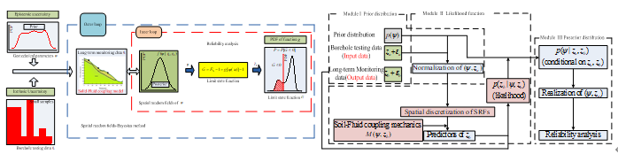
��Ͽ�������ʻ������������ҹ������ֺ��Ķ��������Ч��չ���¼���Ѿ���Ϊ��Ͽ���������ֺ����ε�һ����Ҫ������ѧ�빤�̿�ѧѧԺ˶ʿ�о����ڹ��ʶ�����ѧ�ڿ���Landslides���������ġ�Reliability analysis of unsaturated soil slope stability using spatial random fields-based Bayesian method...
LANDSLIDE HAZARD ZONATION MAPPING OF CHAMOLI LANDSLIDES IN REMOTE SENSING AND GIS ENVIRONMENT
Landslides Chamoli Remote Sensing Hazard, Himalaya
<
2019/2/27
Landslides are very common problem in hilly terrain. Chamoli region of Himalaya is highest sensitive zone of the landslide hazards. The purpose of Chamoli landslide study, to observe the important ter...
UNCERTAINTY IN LANDSLIDES VOLUME ESTIMATION USING DEMs GENERATED BY AIRBORNE LASER SCANNER AND PHOTOGRAMMETRY DATA
ALS Digital Elevation Model DoD Volume estimation landslide airborne sensor
<
2018/4/18
The purpose of this paper is to identify an approach able to estimate the uncertainty related to the measure of terrain volume generated after a landslide. The survey of the area interested of landsli...
REMOTE SENSING TECHNIQUES IN DISASTER MANAGEMENT: AMYNTEON MINE LANDSLIDES, GREECE
remote sensing digital image processing image interpretation fault zones disaster management landslides
<
2018/4/18
Natural or man-made disasters are phenomena that can affect large areas and have many environmental, societal and economic impacts. Landslides are among the major disasters of large scale that may aff...
UNCERTAINTY IN LANDSLIDES VOLUME ESTIMATION USING DEMs GENERATED BY AIRBORNE LASER SCANNER AND PHOTOGRAMMETRY DATA
ALS Digital Elevation Model DoD Volume estimation landslide airborne sensor
<
2018/5/8
The purpose of this paper is to identify an approach able to estimate the uncertainty related to the measure of terrain volume generated after a landslide. The survey of the area interested of landsli...
REMOTE SENSING TECHNIQUES IN DISASTER MANAGEMENT: AMYNTEON MINE LANDSLIDES, GREECE
remote sensing, digital image processing, image interpretation, fault zones, disaster management, landslides
<
2018/5/8
Natural or man-made disasters are phenomena that can affect large areas and have many environmental, societal and economic impacts. Landslides are among the major disasters of large scale that may aff...
DETECTION OF LANDSLIDES WITH SAR POLARYMETRY: CASE STUDY OF SOUTH-EASTERN COLOMBIA
Backscattering Coefficient Dispersion Mechanism Landslides Polarimetry SAR (PolSAR) Entropy �C Alpha Parameter Classification Principal Component Analysis
<
2018/5/8
SAR polarimetry (PolSAR) is a method that can be used to investigate landslides. Polarimetric scattering power decomposition allows to separate the total power received by the SAR antenna, which is di...
LANDSLIDES EXTRACTION FROM DIVERSE REMOTE SENSING DATA SOURCES USING SEMANTIC REASONING SCHEME
Landslides Extraction Semantic Reasoning High Resolution Imagery First Order Logic Disaster Management Prover9
<
2016/11/30
Using high resolution satellite imagery to detect, analyse and extract landslides automatically is an increasing strong support for rapid response after disaster. This requires the formulation of proc...
LANDSLIDES IDENTIFICATION USING AIRBORNE LASER SCANNING DATA DERIVED TOPOGRAPHIC TERRAIN ATTRIBUTES AND SUPPORT VECTOR MACHINE CLASSIFICATION
Airborne laser scanning support vector machine landslide mapping Pricncipal Component Analysis
<
2016/11/30
Since the availability of high-resolution Airborne Laser Scanning (ALS) data, substantial progress in geomorphological research, especially in landslide analysis, has been carried out. First and secon...
SEGMENTATION AND CLASSIFICATION OF NEPAL EARTHQUAKE INDUCED LANDSLIDES USING SENTINEL-1 PRODUCT
Sentinel-1 Landslide Earthquake SAR Polarimetry Texture Segmentation Classification Nepal
<
2016/11/24
On April 26, 2015, an earthquake of magnitude 7.8 on the Richter scale occurred, with epicentre at Barpak (28��12'20''N,84��44'19''E), Nepal. Landslides induced due to the earthquake and its aftershock ...
ANALYSIS OF LANDSLIDES BASED ON DISPLACEMENTS OF LINES
UAS photogrammetry landslide road linear elements
<
2016/11/23
Nowadays, the development of UAS has allowed the obtaining of high resolution and accurate cartographic products, such as DSMs and orthoimages. These products can be used in studies of the evolution o...
MAPPING LANDSLIDES IN LUNAR IMPACT CRATERS USING CHEBYSHEV POLYNOMIALS AND DEM��S
Planetary mapping Impact craters Landslides Chebyshev polynomials
<
2016/11/15
Geological slope failure processes have been observed on the Moon surface for decades, nevertheless a detailed and exhaustive lunar landslide inventory has not been produced yet. For a preliminary sur...
�й��о����������а�-��
- ���ڼ���...
�й�ѧ���ڿ����а�-��
- ���ڼ���...
�����ѧ���л������а�-��
- ���ڼ���...
�й���ѧ���а�-��
- ���ڼ���...
�ˡ���-ƪ
- ���ڼ���...
�Ρ���-ƪ
- ���ڼ���...
��������-ƪ
- ���ڼ���...
�������� -ƪ
- ���ڼ���...
֪ʶҪ��-ƪ
- ���ڼ���...
���ʶ�̬-ƪ
- ���ڼ���...
��������-ƪ
- ���ڼ���...
ѧ��ָ��-ƪ
- ���ڼ���...
ѧ��վ��-ƪ
- ���ڼ���...