
搜索结果: 1-15 共查到“理学 Sentinel-2”相关记录18条 . 查询时间(0.042 秒)
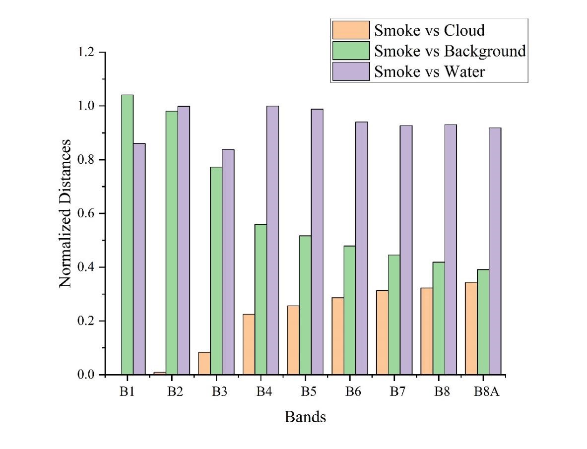
东北地理所在基于Sentinel-2遥感数据的秸秆燃烧烟羽检测方面取得重要进展(图)
遥感数据 大气悬浮颗粒 生物质燃烧
<
2023/7/10
中国东北农村地区,春秋季节由于秸秆的大量焚烧,大气悬浮颗粒物含量明显升高,PM10和PM2.5可以升高0.5至4倍。露天生物质燃烧(Open-air biomass burning,OBB)是微量气体污染物和细小碳质颗粒物(particulate matter,PM)的主要排放源。大面积、高强度的露天焚烧秸秆会对区域的空气质量以及当地的公共卫生安全造成损害。秸秆燃烧检测主要是靠检测秸秆焚烧的产物来...
基于Landsat与Sentinel-3A卫星数据的当惹雍错1988-2018年湖泊水位-水量变化及归因
Sentinel-3 合成孔径雷达 Landsat 水位 水量 当惹雍错
<
2020/9/16
湖泊变化是气候变化的指示器.为探索利用单一短时间尺度的卫星水位数据源估算长时间序列的湖泊水量变化的可行性,本文利用短时间尺度(2016―2018年) Sentinel-3A合成孔径雷达高度计(SRAL)作为唯一卫星水位数据源,以藏北高原内陆湖泊当惹雍错为例,结合基于Landsat光学遥感数据提取的1988―2018年的湖泊面积,综合分析2016―2018年间的非结冰期遥感湖泊面积与遥感湖泊水位变化...
HIGH-RESOLUTION ENHANCED PRODUCT BASED ON SMAP ACTIVE-PASSIVE APPROACH USING SENTINEL 1A AND 1B SAR DATA
soil moisture microwave remote sensing active-passive algorithm SMAP Sentinel-1A -1B
<
2019/2/27
SMAP project released a new enhanced high-resolution (3km) soil moisture active-passive product. This product is obtained by combining the SMAP radiometer data and the Sentinel-1A and -1B Synthetic Ap...
ATMOSPHERIC PHASE DELAY CORRECTION OF D-INSAR BASED ON SENTINEL-1A
Atmospheric Phase Sentinel-1A, D-InSAR Tropospheric Delay Maps GACOS Subsidence Monitoring Yellow River Delta
<
2018/5/14
In this paper, we used the Generic Atmospheric Correction Online Service for InSAR (GACOS) tropospheric delay maps to correct the atmospheric phase delay of the differential interferometric synthetic ...
GLACIER FRONTAL LINE EXTRACTION FROM SENTINEL-1 SAR IMAGERY IN PRYDZ AREA
SAR Glacier Frontal Sentinel-1 CFAR Profile analysis
<
2018/5/14
Synthetic Aperture Radar (SAR) can provide all-day and all-night observation of the earth in all-weather conditions with high resolution, and it is widely used in polar research including sea ice, sea...
ATMOSPHERIC PHASE DELAY IN SENTINEL SAR INTERFEROMETRY
Interferometric SAR differential interferometry tropospheric path delay
<
2018/5/14
The repeat-pass Synthetic Aperture Radio Detection and Ranging (RADAR) Interferometry (InSAR) has been a widely used geodetic technique for observing the Earth’s surface, especially for mapping the Ea...
ESTIMATION OF STATIC COULOMB STRESS CHANGE AND STRONG MOTION SIMULATION FOR JIUZHAIGOU 7.0 EARTHQUAKE BASE ON SENTINEL-1 INSAR DATA INVERSION
InSAR Coulomb Stress Change Slip Inversion Strong Motion Aftershocks Slip Model Jiuzhaigou Earthquake
<
2018/5/15
On August 8, 2017, an earthquake of M 7.0 occurred at Jiuzhaigou. Based on the Sentinel-1 satellite InSAR data, we obtained coseismic deformation field and inverted the source slip model. Result...
COMPARISON OF VEGETATION INDICES FROM RPAS AND SENTINEL-2 IMAGERY FOR DETECTING PERMANENT PASTURES
remotely piloted aircraft systems RPAS UAV Sentinel-2 Copernicus NDVI vegetation indices agricultural monitoring
<
2018/5/15
Permanent pastures (PP) are defined as grasslands, which are not subjected to any tillage, but only to natural growth. They are important for local economies in the production of fodder and pastures (...
APPLICATION OF DEEP LEARNING OF MULTI-TEMPORAL SENTINEL-1 IMAGES FOR THE CLASSIFICATION OF COASTAL VEGETATION ZONE OF THE DANUBE DELTA
Deep Learning vegetation Danube Delta temporal series Sentinel-1
<
2018/5/15
Land cover is a fundamental variable for regional planning, as well as for the study and understanding of the environment. This work propose a multi-temporal approach relying on a fusion of radar mult...
EFFECT OF THE TRAINING SET CONFIGURATION ON SENTINEL-2-BASED URBAN LOCAL CLIMATE ZONE CLASSIFICATION
Label Noise Canonical Correlation Forests (CCFs) Local Climate Zones (LCZs) Sentinel-2 Spectral features Classification Open Street Map (OSM)
<
2018/6/4
As any supervised classification procedure, also Local Climate Zone (LCZ) mapping requires reliable reference data. These are usually created manually and inevitably include label noise, caused by the...
SAFETY PROJECT: SENTINEL-1 BASED TOOLS FOR GEOHAZARDS MONITORING AND MANAGEMENT
Safety Monitoring Geohazard SAR, PSI
<
2018/4/18
SAFETY is a two-years European project started the 1st January 2016 and ended the 1st January 2018. The general aim of the project was to develop a methodology and tools in order to exploit Sentinel-1...
SAFETY PROJECT: SENTINEL-1 BASED TOOLS FOR GEOHAZARDS MONITORING AND MANAGEMENT
Safety Monitoring Geohazard SAR PSI
<
2018/5/8
SAFETY is a two-years European project started the 1st January 2016 and ended the 1st January 2018. The general aim of the project was to develop a methodology and tools in order to exploit Sentinel-1...
文中以Sentinel-1A升、降轨为数据源,利用"二轨法"获取门源地震的同震形变场,结果显示门源地震以抬升形变为主,其抬升形变值明显大于沉降形变值,升、降轨抬升区最大视线向形变分别为6cm、8cm。同时基于Okada位错模型,构建不同倾向断层模型,以升、降轨形变场数据为约束联合反演得到此次地震的断层滑动分布及震源参数,最佳断层模型参数分别为:倾角43°,走向128°,平均滑动角85°,最大滑动量...
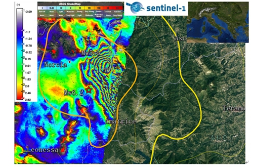
中国科学院测量与地球物理研究所利用Sentinel-1A卫星InSAR数据获取意大利佩鲁贾地震的同震干涉图(图)
中国科学院测量与地球物理研究所 Sentinel-1A卫星InSAR数据 意大利佩鲁贾地震 同震干涉图
<
2016/8/30
北京时间2016年8月24日9时36分(UTC: 2016-08-24 01:36:33),在意大利中部城市佩鲁贾附近发生Mw 6.2地震(42.714°N,13.172°E),震源深度10.0 km(USGS)。震后约1小时,于2016年8月24日10时33分翁布里亚大区(42.822°N 13.126°E)又发生Mw5.5地震,震源深度10.0 km(USGS)。意大利中部地区阿...
2014年8月24日,在美国加州旧金山海湾北部的纳帕地区发生了MW6.1地震.发震断层是西纳帕断裂系统中的一部分,但是该断层之前并未被足够重视.本文利用欧洲空间局最近发射成功并刚刚投入使用的Sentinel-1A卫星获取的第一对同震干涉像对(20140807-20140831),得到了该地震的地表同震形变场,结合震后24 h内区域GPS同震形变资料作为约束条件,反演了纳帕地震的断层几何参数以及滑动...